The District of Columbia is filled with history of numerous events that took place within the past couple centuries. I began my primary research on the website for National Archives and Records Administration. The section I went to was the Digital Copies Records Search that has different forms of multimedia such as images of historic events.
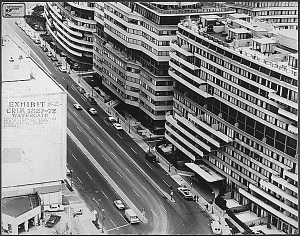
I looked at images from the Watergate after it was broken into by five burglars.
The sources came from the U.S. District Court for the District of Columbia, the National Archives Rotunda under exhibit history: “American Originals” and the National Archives at College Park, MD.
The image was taken in North West Washington D.C of the Watergate building. The photograph was used in the trial of Watergate burglar G. Gordon Liddy to provide an image to the court. It is clear that this is the Watergate building for two reasons, one it is clearly documented under the National Archives and the building is still intact today making it clear that it is the same structure.
The Digital Copies Records gives a basic summary of what the images were used for and their significance. Each archive is broken down into 5 sections. Consisting of Details, Scope and Content, Archived Copies, Digital Copies, and Hierarchy.
The types of archival materials used were photographs and other graphic materials. Other information given is the contacts, information on restriction levels, record types, variant control numbers, and index terms to locate the image.
The Archived Copies gives information on were to find the actual printed image(s) and what type of media it was, for example the image is printed on paper.
For this primary source I went through each section an analyzed what information was given and how it was helpful to the primary image. The National Archive website is useful for multimedia and it was easy to navigate. The images itself didn’t give off that much information about the Watergate break in but was acknowledged as important photographs because of its usage in trial.

Found under Exhibit History:”American Originals,” December 1997-December 1998, National Archives Rotunda, Washington, DC, Exhibit No. 624.0220
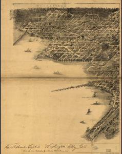
The second primary source I researched was from the Map section of the Library of Congress. The map I chose was an image of Georgetown, Foggy Bottom, and Potomac waterfront. in 1883. It was published in Baltimore and gives a birds eye perspective of what these areas looked like in the 19th century. There is still a lot of vegetation in the map, showing that at this time in history Georgetown and Foggy Bottom were still in the process of development.
The sources of this map comes from A. Sachse & Co (Baltimore, MD) and Library of Congress Geography and Map Division.
The contextualization of the map is not drawn to scale making the actual sizes of locations inaccurate. Certain details of these areas could have been left out since it was only a drawing and not a photograph.

The District of Columbia. Library of Congress Catalog Number: 75694904. Digital ID: g3851a pm001090. Call number: G3851.A3 1883. S3
The Library of Congress Maps section provides information about the image including the title, contributor names, where it was published and created, notes, the size, where it can be found in the Library of Congress, and the digital ID.
The maps are provided to the public as a tool for education and research purposes.
I found that working with Maps as a primary resource can be more challenging to work with because details could have been left out due to the fact that most maps in the 18-20th century were hand drawn. That makes the process of getting concrete information on a specific location difficult because it is not certain whether or not the map has all of the information provided.


